Author: Nathan Willis
Navicore is Nokia’s GPS mapping and navigation program for the N800 Internet Tablet. The kit comes with a Bluetooth GPS receiver, car-mounting hardware, and a memory card containing the Navicore Personal software and map collection. If you have an N800, it’s a great travel aid.
Installation is a snap; just pop the miniSD card it comes on into either of the N800’s card slots (using the provided miniSD-to-SD adapter), then double-click on the installer package from the file manager. The first time you launch Navicore, you must enter the activation code that accompanies the kit, and select your language and location preferences.
The memory card for the US version of the kit contains map data divided into three sets: Alaska-Canada, Eastern US, and Western US. Navicore loads only one of these sets into memory at a time, and you can switch between them within the application settings.
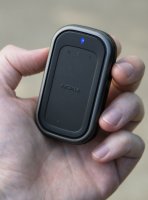
The GPS receiver is hard plastic biscuit with rubberized edges, almost featureless on its surface. It is powered by a Nokia-standard BL-5C battery, and uses the same recharge connector as the N800 itself.
The GPS receiver’s only button is its power switch; when it’s on a green LED lights up. A Bluetooth connection illuminates a blue LED, and GPS lock shows white. After scanning for and locating the receiver manually the first time, Navicore will automatically locate and pair with the receiver via Bluetooth. Navicore activates the GPS antenna, which in my tests was very sensitive — generally acquiring a fix indoors in a matter of seconds.
Where do you want to go today?
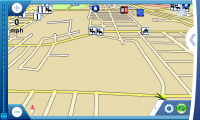
Navicore launches in full-screen mode, wisely devoting the bulk of the display’s real estate to displaying literal real estate — minus the space required for a pair of zoom in/out buttons on the left, and preferences and navigation buttons on the right.
Getting from point A to point B begins with tapping the navigation button (an angle bracket). The options presented are Find route, Clear route, Find detour, Find location, Plan route, and Settings.
“Find location” lets you search the map database for street addresses and points-of-interest (POI), as well as your own recently visited location history, personal “favorites,” and exact latitude-longitude coordinates. “Find route” brings up the same options as “Find location,” but automatically calculates a route from your present location to the destination once you make a selection. “Plan route” lets you stack and rearrange a list of destinations before calculating directions.
Searching for street addresses is a three-step process. First you enter the city name, after which Navicore retrieves a list of matching cities from the database, from which you select the one you want. Navicore then brings up a street name search for the chosen city, and once you have found the correct street, a search for the address number.
Because Navicore makes you start over from scratch and walk through that process for every location, you soon begin to appreciate the favorites list. To add a location to your favorites, it must be visible on the map. When you touch and hold down the cursor for two seconds (via stylus or fingertip), a context menu pops up. Click the star icon, and the location under the cursor gets added to your favorites, initially under its street address, but you can edit the name for convenience.
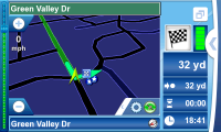
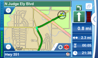
Once you have selected a destination and Navicore has found a route to it, the display switches from map mode to route mode. The chosen route is highlighted in green with arrows indicating direction. As you move, the map follows your progress, with your current location in the center. The zoom level is adjusted to your speed.
About a third of the screen is taken up by route information. The right side of the display indicates the direction of your next two turns, your approximate remaining distance, your estimated travel time, and your estimated arrival time.
If you have voice navigation activated, you get vocal turn-by-turn directions, in either American or metric units. You even get your choice of disembodied voices to hear: there is the happy-go-lucky “Todd,” the bold, decisive “Sara,” and my personal favorite, the slightly William Daniels-esque “Christopher.” When you make a wrong turn (and you will), Navicore automatically recalculates the route to adjust for your new position.
Of course, certain destinations are less desirable than others, so Navicore optionally lets you sound an alarm when you get within range of a POI. You can specify alarms by distance and category of POI, drawing on the software’s database of gas stations, entertainment venues, museums, parks, schools, casinos, restaurants, wireless hotspots, and just about everything else. I immediately set alarms for operas, embassies, and “leisure centres” because I’m curious as to my proximity to the first two, and because I couldn’t imagine what the third meant.
Location, location, location … location
All of that GPS and software goodness sounds great, but the real test is how well it performs on the road.
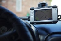
Unless you have a copilot, you will need to attach the N800 somewhere in your car where you can see it, and for that Nokia supplies a plastic, suction-cup-backed windshield mount. It appears to be a standardized Nokia product onto which interchangeable clips fit to hold other Nokia phones. The suction cup is lever-activated, forming a seal tight enough that it held my N800 in place even on my hometown’s decidedly rustic road surfaces. My only gripe is that it has left-right and up-down adjustment for the tablet, but it does not permit rotation without disassembly.
Eager to navigate, I loaded up the N800 into the windshield mount, tossed the GPS receiver into a drink holder, and headed out onto the open road. I started by plugging in the addresses of some friends’ houses, well-known retail stores, and local landmarks, just to see how good Navicore’s directions were.
Minute by minute, the directions were great. William Daniels told me about upcoming turns blocks in advance, then again when we were right on top of the intersection. The amount of advance warning seemed to vary based on vehicle speed, but I did not turn up any explicit reference to that feature in the manual so it could just be my imagination. The map updates your position fast enough that you can always see the next 10 or 15 seconds of road ahead of you, but the zoom level stays tight enough that you can see your immediate surroundings in suitable detail — kudos to the programming team on that feature.
Though it is my own fault, the first few times I drove with Navicore running, I found myself looking at the screen (instead of the road) more than I should have. I couldn’t help it; seeing that real-time map adjust on the fly is too cool. Plus, I became fascinated by watching how fast the GPS receiver said I was moving as compared with the vehicle’s speedometer. My car’s speedometer is currently a bit of an abstract affair; I removed all the gauge needles and painted them a while back, and getting them seated correctly again involves some patience.
The first two test days were overcast or rainy, and I stuck with Navicore’s normal map color scheme to great success. Later I had trouble seeing the screen in harsh daylight, even when I switched to the bright-light, high-contrast color scheme. Success here is probably vehicle-dependent — thanks to the shape of my windshield, the N800 stayed in direct light, and it was very hard to read the map while moving.
The success of the voice navigation system is also vehicle-dependent. Even with the N800’s system volume and Navicore’s internal volume both set to maximum, William Daniels barely registered over my car’s beefy 1.8L, four-cylinder Mazda engine once I got above 40 mph. In a quiet car, you would probably fare fine as long as you kept the radio off, but roadster drivers and ‘Cuda owners: you’re probably out of luck.
Maps and legends
As nice as using Navicore is, I had some significant trouble with the map data itself. About one third of the street addresses I looked up (and took directly from the phone book) were reported as not found in the database. And I’m not talking about new buildings, either, but established businesses. Several residential addresses were listed as a block or more off from the actual locations, there were dog-leg turns marked as straight, and phantom streets were listed in empty fields.
Worse, on the very first route that I programmed in, Navicore directed me to turn onto a street that had been closed and turned into private parking lots 20 years ago. In contrast, Google Maps’ satellite imagery is a few years old for this area, but it is certainly using data from this millennium.
On one occasion, the directions instructed me to get onto and then off of the loop multiple times in the course of one half-mile stretch of road (note for non-Texans: all cities in Texas are built with circular freeways in loops around the outside edge, rather than arteries through the middle; it is behavior the city planners of today no doubt inherited from their pioneer-era predecessors, who were reportedly fond of “circling the wagons”).
I am aware that Abilene, Texas, is not a wildly popular destination, but isn’t that a good reason for needing a GPS system? Building-accurate maps of well-trafficked areas like Manhattan and London are a dime a dozen — free if you can settle for street-accurate. You need navigation help for those places that are less well-known. I know my own town well enough to recognize how many mistakes there are in these maps, and that leaves me without confidence that Navicore would direct me through someplace completely unfamiliar.
Additional usage brought some user interface nitpicks to the surface. In route mode, fully one-third of the screen is given over to the “stats” panel — space that should be given back to the map. Same too for the unnecessary window border (it is full-screen, after all), the gear icon that duplicates the function of the GPS icon, and the zoom buttons that sit outside the zoom slider. When selecting cities from Navicore’s database matches, the entire city name is displayed, but when selecting streets, only the first letter is displayed (e.g., “A… B… C…”), though the screen is 800 by 480; there is plenty of room.
Some interface elements still puzzle me. For instance, what is the purpose of the red/green bar graph situated on the right side of the screen, in route mode only? It is not mentioned in any of the documentation, and I could not figure out what made it change color periodically, nor what each color indicated. Why, too, are there separate “preferences” and “settings” screens, with overlapping (but not identical) options? Why is the only exit button hidden on the quick launch screen?
Linux in hand — but not on the desktop
I like to nitpick UIs, but interface quirks ultimately do not count for much when you consider whether or not an application makes the grade. I can live with Navicore’s larger-than-life stats panel, split preferences and settings screens, and even imperfect map coverage.
Sadly, there is one strike against Navicore that I see no way around for desktop Linux users. The N800 Navigation Kit ships with a memory card containing one region’s maps (say, North America). The Navicore Web site contains additional maps for other regions of the world, additional POIs, and updates to the map database — but you cannot access or install any of that data without running Windows. I am not talking about OS-detection through the browser, either: the only way to download updated data to your device is by downloading a Windows executable “update tool” from the site. End of story.
Nokia provides such tools to N800 and 770 owners for firmware updating as well, but it also provides a command-line tool for Linux and Mac users that works just as well (in truth, there is no need for the updater to be graphical). Until Navicore releases such a map data updater, it looks like Linux users will be stuck with one region’s data, with no updates. And that’s a shame.
Go west, young tablet
Altogether, Navicore is a smooth, easy-to-use application. Regarding my own experiences navigating through Abilene, missing or outdated map data is a problem for any map source — software or otherwise. But the combined assets of turn-by-turn navigation, route calculation, and quality GPS location far outweigh the risks of encountering a closed road. As an added bonus, you get a great little Bluetooth GPS receiver that works with any GPS-aware software, for the tablet or otherwise.
The form factor, hardware, and storage capacity of the N800 put it light years ahead of a cell phone for this kind of map-based navigation. If you can stick to one region, or if you run Windows on your desktop computer, then the Navigation Kit is a killer app for the N800 tablet. Here’s hoping that Nokia and Navicore come up with a solution for those of us who run other operating systems as well.
Categories:
- Reviews
- Handheld Devices

